History of Maritime Interception Operations, Lebanon (2006–Present) events and knowledge international navigation and security issues History of Maritime Interception Operations, Lebanon (2006–Present)
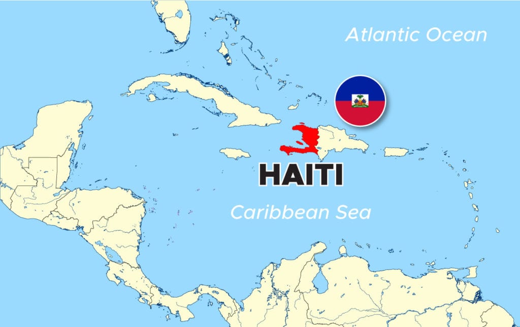
admin Haiti, Maritime Interception Operations, multinational force (MNF), OAS, Organization of American States, UNSC 0 Comments History of Maritime Interception Operations, Haiti (1993–1996)
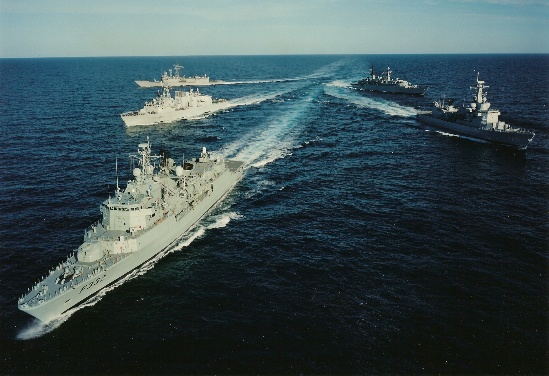
admin Adriatic Sea, Maritime Interception Operations, NATO, The Former Yugoslavia, UNSC, WEU 0 Comments History of Maritime Interception Operations, The Former Yugoslavia (1992–1996)
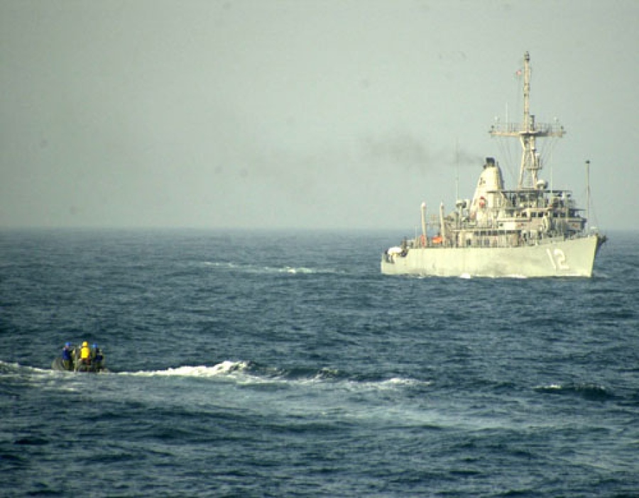
admin Iraq, Maritime Interception Force (MIF), Maritime Interception Operations, UN Charter, UNSC 0 Comments History of Maritime Interception Operations, Iraq (1990–2003)
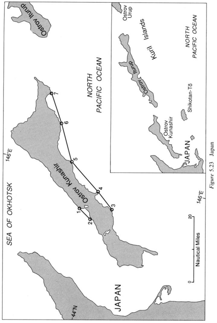
admin extensive coastline, Kamchatka Peninsula, Kara Sea, North Pacific, russia, Sea of Japan, Sea of Okhotsk, Tartar Strait, USSR, Vrangelya Island 0 Comments Baselines Drawn under Article 4 ( LOSC Article 7) which Subvert Other Convention Provisions, USSR(now Russia)case
admin de Sangomar and the Gambian border, Senegal, straight baseline, straight baseline system 0 Comments Baselines Drawn under Article 4 ( LOSC Article 7) which Subvert Other Convention Provisions, Senegal case
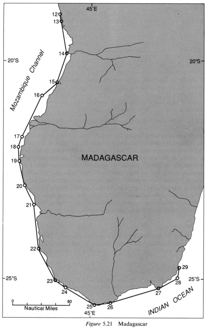
admin fringing islands, Madagascar, straight baseline 0 Comments Baselines Drawn under Article 4 ( LOSC Article 7) which Subvert Other Convention Provisions, Madagascar case
admin Cabo de Ia Vela, Caribbean Coast, Colombia, Golfo de Venezuela, Juridical Bays, Punta de Gallinas, Straight Baselines 0 Comments Baselines Drawn under Article 4 ( LOSC Article 7) which Subvert Other Convention Provisions, Colombia (Caribbean Coast) case
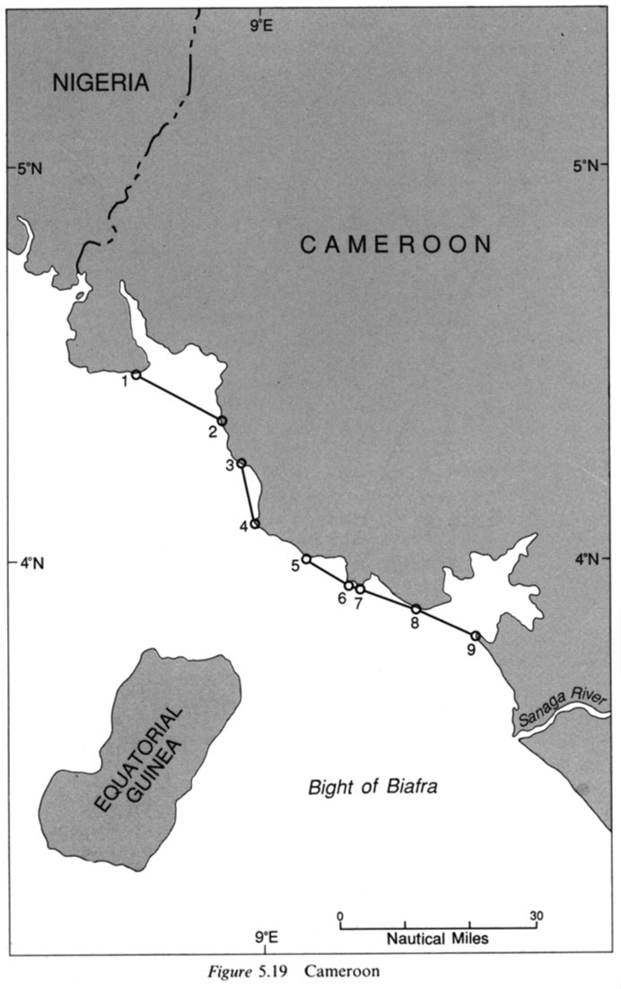
admin Cameroon, enclose juridical bays, low-water mark, River Bimbia, straight baseline 0 Comments Baselines Drawn under Article 4 ( LOSC Article 7) which Subvert Other Convention Provisions, Cameroon case
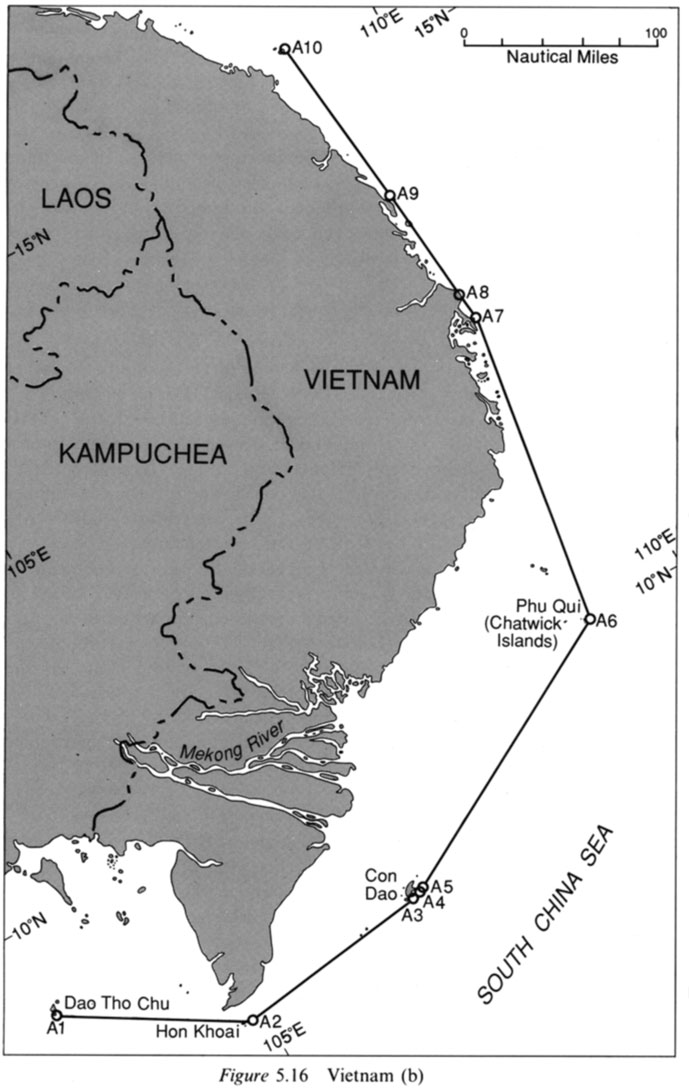
admin Con Dao, Dao Tho Chu, Hon Khoai, Mekong delta, Phu Qui group (Chatwick Islands), straight baseline, Straight Baselines of Vietnam, Vietnam, VIETNAM: STRAIGHT BASELINE CLAIM, What are the territorial waters of Vietnam?, What Vietnam could gain from redrawing its baselines 0 Comments STATE CLAIMS IN VIOLATION OF ARTICLE 4 (LOSC ARTICLE 7), Vietnam case
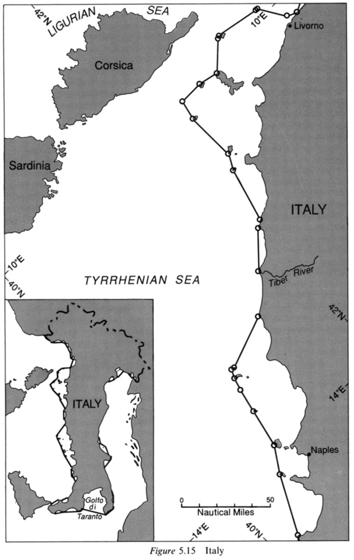
admin Gulf of Taranto, internal waters, italy, juridical bay, Juridical Bays, Ligurian Sea, straight baseline 0 Comments STATE CLAIMS IN VIOLATION OF ARTICLE 4 (LOSC ARTICLE 7), Italy case
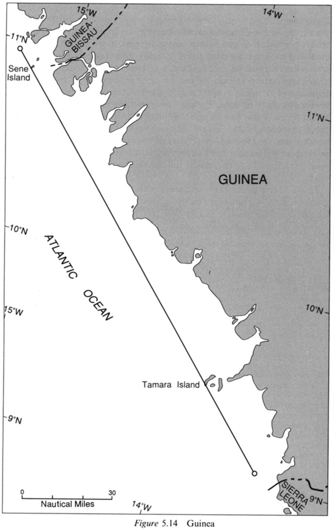
admin Guinea, Guinea-Bissau, Guinean coastline, maritime boundary, north and Tamara Island, straight baseline 0 Comments STATE CLAIMS IN VIOLATION OF ARTICLE 4 (LOSC ARTICLE 7), Guinea case
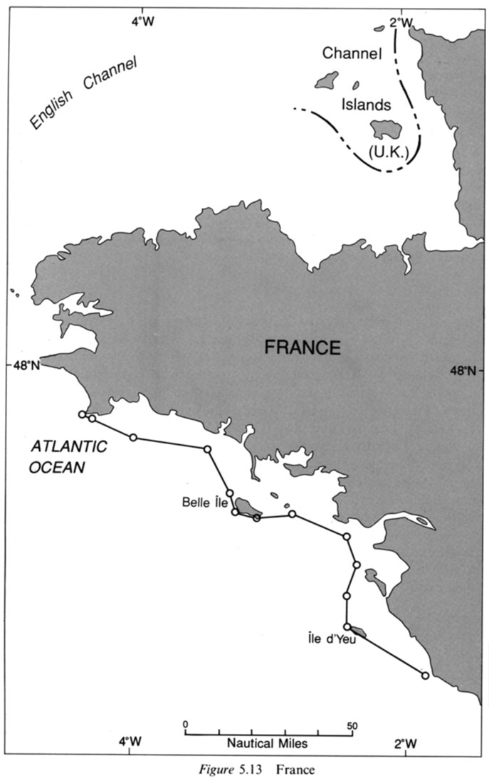
admin france, straight baseline 0 Comments STATE CLAIMS IN VIOLATION OF ARTICLE 4 (LOSC ARTICLE 7), France case
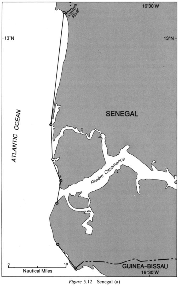
admin Riviere Casamance, Senegal, straight baseline 0 Comments STATE CLAIMS IN VIOLATION OF ARTICLE 4 (LOSC ARTICLE 7), Senegal case
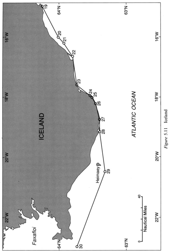
admin lceland, straight baseline 0 Comments STATE CLAIMS IN VIOLATION OF ARTICLE 4 (LOSC ARTICLE 7), lceland case
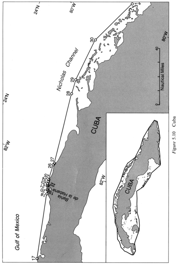
admin Common Heritage, cuba, CUBA – MARITIME CLAIMS, Cuba maritime claims, Cuba Maritime claims about straight baseline, Cuba Straight Baselines, How far is Cuba from mainland USA?, Nicholas Channel, straight baseline, What are boundaries in Cuba?, Where do Cuban waters begin? 0 Comments STATE CLAIMS IN VIOLATION OF ARTICLE 4 (LOSC ARTICLE 7), Cuba case
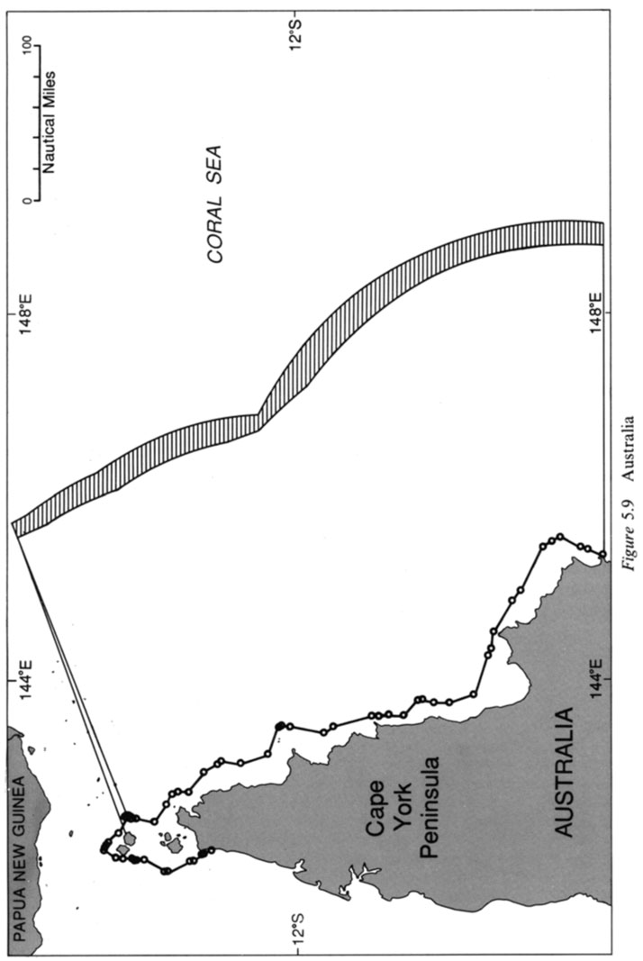
admin Australia, Cape York Peninsula, Coral Sea, straight baseline 0 Comments STATE CLAIMS IN VIOLATION OF ARTICLE 4 (LOSC ARTICLE 7), Australia case
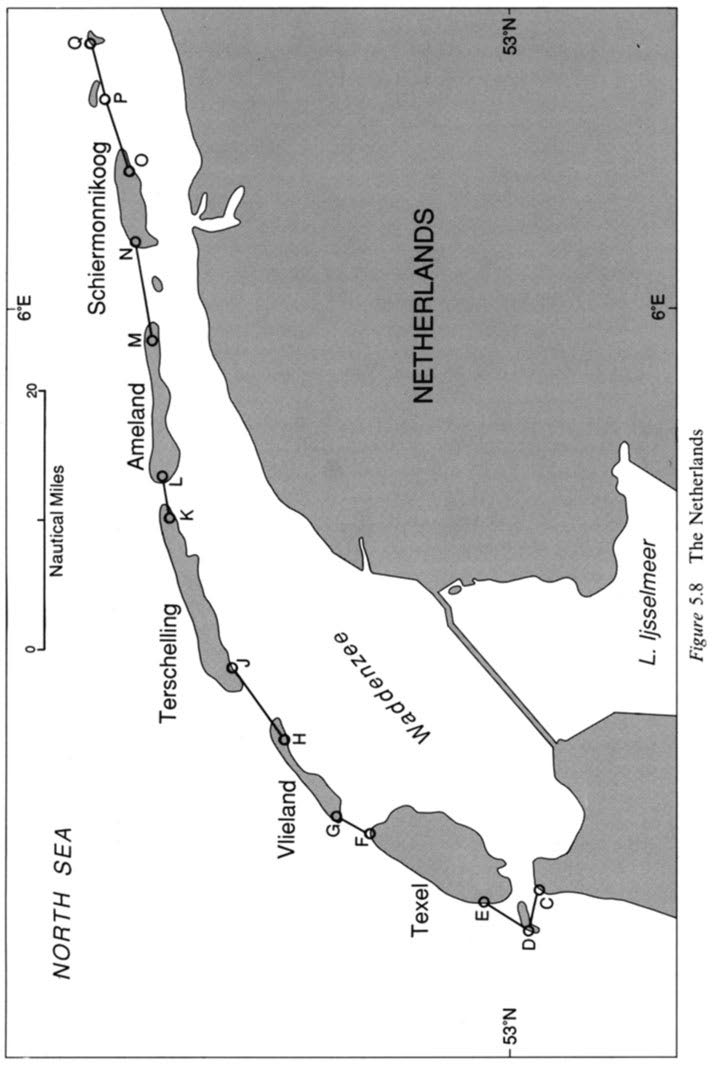
admin netherlands, straight baseline 0 Comments STATE CLAIMS IN SUBSTANTIAL CONFORMITY WITH ARTICLE 4 (LOSC ARTICLE 7), The Netherlands case
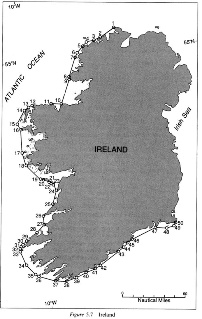
admin internal waters, lreland, straight baseline 0 Comments STATE CLAIMS IN SUBSTANTIAL CONFORMITY WITH ARTICLE 4 (LOSC ARTICLE 7), lreland case
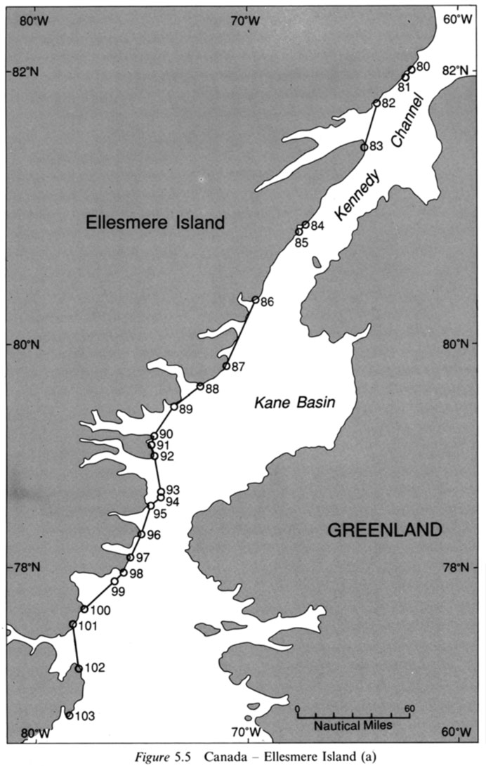
admin Canada, Canadian straight baseline, Scandinavian coasts 0 Comments STATE CLAIMS IN SUBSTANTIAL CONFORMITY WITH ARTICLE 4 (LOSC ARTICLE 7), Canada case
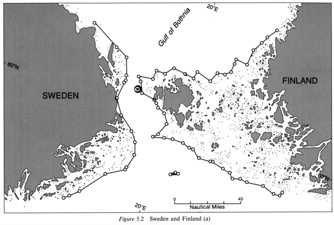
admin Finland, LOSC, Norway, Sweden 0 Comments STATE CLAIMS IN SUBSTANTIAL CONFORMITY WITH ARTICLE 4 (LOSC ARTICLE 7), Norway, Sweden, and Finland cases
admin China, continental shelf, exclusive economic zone, LOS Convention, Taiwan, Yellow Sea 0 Comments legal issues and marine laws of mainland China and Taiwan
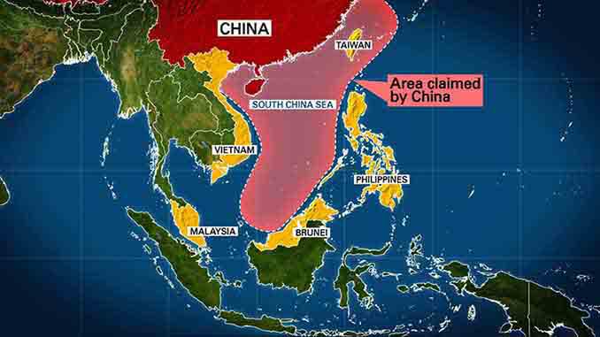
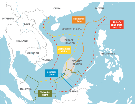
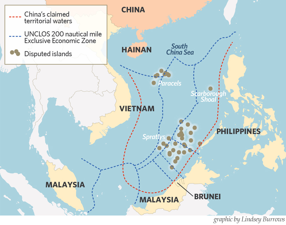
admin artificial islands, China, China's claimed straight baselines., Commission on the Limits of the Continental Shelf, contiguous zone, continental shelf, Convention on the Continental Shelf, Convention on the High Seas, Convention on the Territorial Sea, Does Taiwan claim South China Sea?, EEZ, exclusive economic zone, How did China influence Southeast Asia culture?, How did developments in China and the rest of East Asia?, How did the cultural traditions of China affect East Asia?, internal waters, Is China considered Eastern Asia?, ISLANDS, low-tide elevations, maritime zone of china, maritime zones, rocks, south china sea, South China Sea dispute, What countries are in the South China Sea?, What happened in South China Sea?, What is the geopolitical significance of the South China Sea?, What is the main dispute of the South China Sea?, What is the main issue in South China Sea?, What makes East Asia unique?, What role did China play in Eastern Asia?, What was happening in China in the 1990s?, Which sea is near China?, Who is the rightful owner of the South China Sea?, Why does Philippines claim the South China Sea?, Why is China interested in South China Sea?, Why is China the core of East Asia?, Why is East Asia so important?, Why is Southeast Asia important to China? 1 Comments International Law in the South China Sea
admin China, China's claimed straight baselines., Does Taiwan claim South China Sea?, How did China influence Southeast Asia culture?, How did developments in China and the rest of East Asia?, How did the cultural traditions of China affect East Asia?, Is China considered Eastern Asia?, maritime zone of china, south china sea, South China Sea dispute, South China Sea Disputes, What countries are in the South China Sea?, What happened in South China Sea?, What is the geopolitical significance of the South China Sea?, What is the main dispute of the South China Sea?, What is the main issue in South China Sea?, What makes East Asia unique?, What role did China play in Eastern Asia?, What was happening in China in the 1990s?, Which sea is near China?, Who is the rightful owner of the South China Sea?, Why does Philippines claim the South China Sea?, Why is China interested in South China Sea?, Why is China the core of East Asia?, Why is East Asia so important?, Why is Southeast Asia important to China? 0 Comments History of the South China Sea Disputes, facts and legal approach
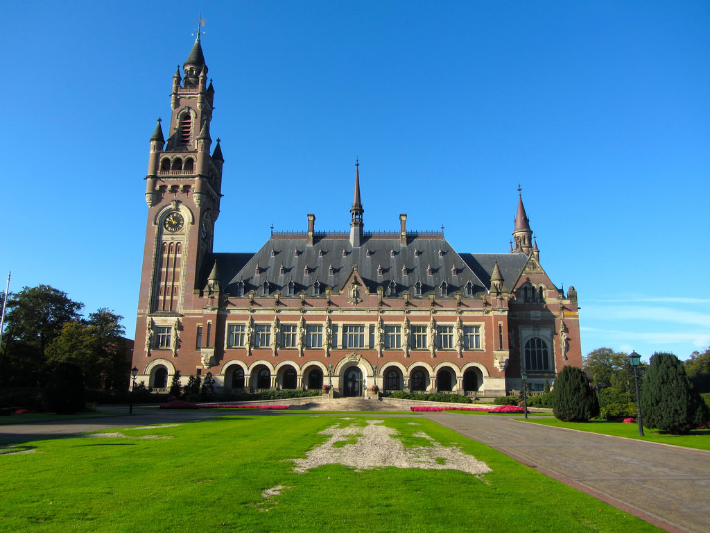
admin International Tribunal for the Law of the Sea, ITLOS, United Nations Convention on the Law of the Sea 0 Comments ITLOS and its structure, duties, Composition,jurisdiction, competence and authorities
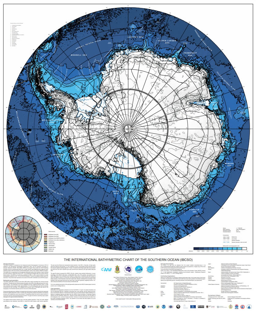
admin Bathymetric Chart, Southern Ocean 0 Comments International Bathymetric Chart of the Southern Ocean (IBCSO)
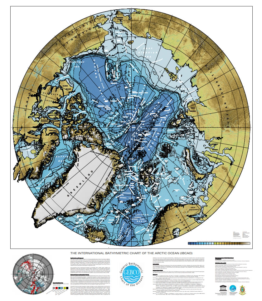
admin Arctic Ocean, Bathymetric Chart 0 Comments International Bathymetric Chart of the Arctic Ocean (IBCAO)
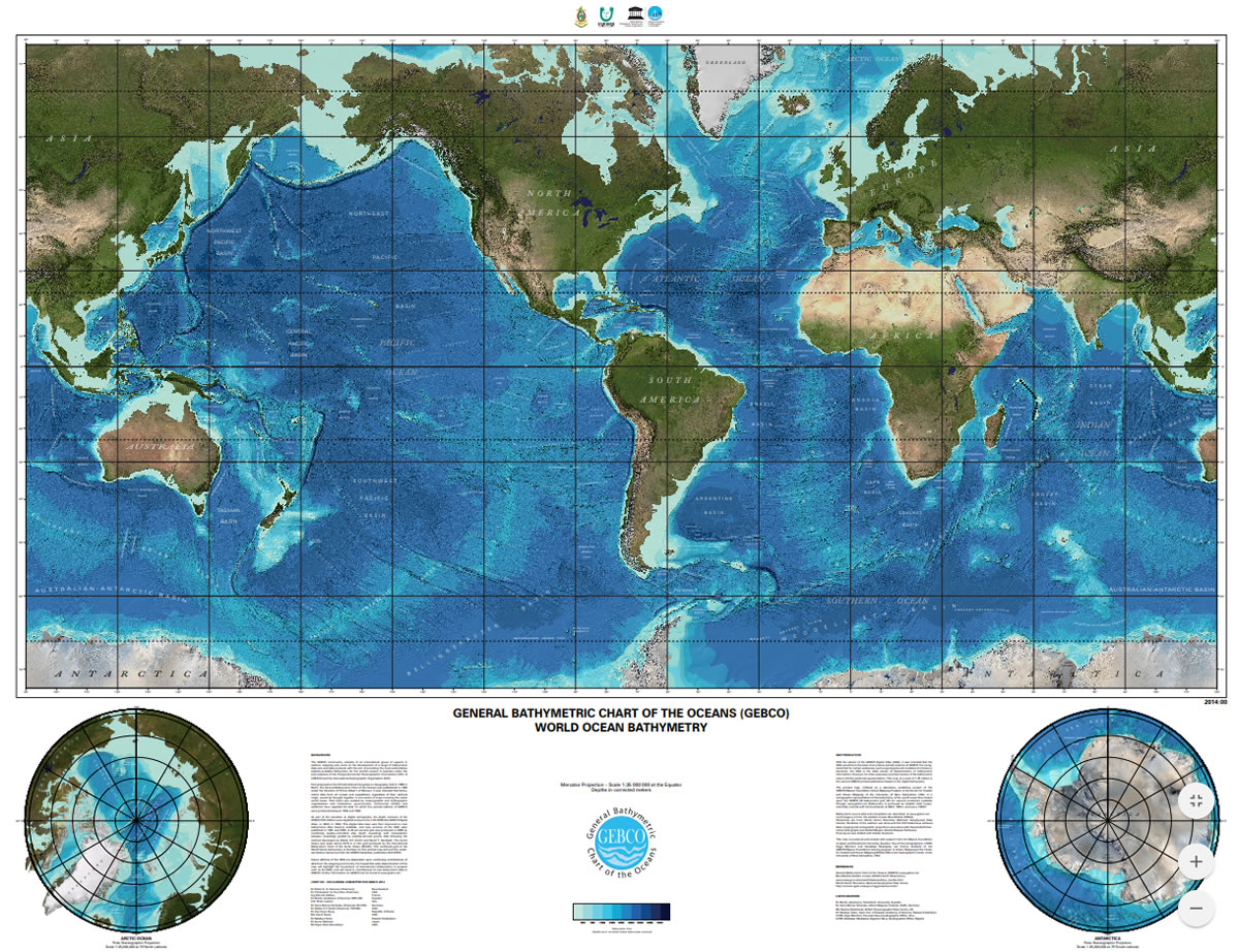
admin Are there 237 nations in the world?, Are there 253 countries in the world?, colour map, high resolution world map, High Resolution World Map - GIS Geography, high resolution world map blank, high resolution world map download, high resolution world map pdf, high resolution world map pdf download, How do you explain maps to students?, How is world map divided?, How many continents are in the world?, How many countries are in world map?, How old is the world map?, How were the first maps created?, Is a physical map?, Is world map wrong?, map, ocean floor, What are the uses of map?, What is a map and its types?, What is a map answer Class 3?, What is a map answer Class 7?, What is a map Class 4?, What is a map Class 5?, What is a map Class 6?, What is a map Class 9?, What is a map for kids?, What is a map lesson?, What is globe and map?, What is map and its importance?, What is map explain?, What is the oldest map in existence?, What is the world map called?, Which country is the richest?, Which map is best in the world?, Who created maps?, Who divided countries?, Who draw the first map of the world?, Who make a map?, Who Mapped the world?, world map 0 Comments GEBCO world map via superzoom capability and world’s ocean floor
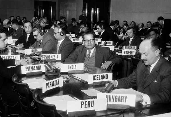
admin Arvid Pardo, marine issues, Third UN Conference on the Law of the Sea (1973–1982), UN General Assembly Resolution 2340 (XXII), UNCLOS III, unclos iii pdf, unclos iii summary, unclos pdf, unclos summary pdf, United Nations Convention on the Law of the Sea 0 Comments The Third UN Conference on the Law of the Sea (1973–1982)
admin exclusive fishery zone (EFZ), Second UN Conference on the Law of the Sea (1960), UNCLOS II 0 Comments The Second UN Conference on the Law of the Sea (1960)
admin continental shelf, Convention on Fishing and Conservation of the Living Resources of the High Seas, Convention on the Continental Shelf, Convention on the High Seas, Convention on the Territorial Sea and the Contiguous Zone, ILC, marine living resources, offshore, Optional Protocol of Signature Concerning the Compulsory Settlement of Disputes, Proclamations on the Continental Shelf and on Fisheries, UN Conference on the Law of the Sea (1958) 0 Comments The First UN Conference on the Law of the Sea (1958)
admin Codification of International Law, customary law, Hague Conference, hague convention on nationality 1930 pdf, Scandinavian countries, territorial waters, the 1930 hague codification conference focused on what issue?, the history of the law of the sea, which of the following is not one of the freedoms of the high seas set out in article 87 of unclos? 0 Comments The Hague Conference for the Codification of International Law (1930)
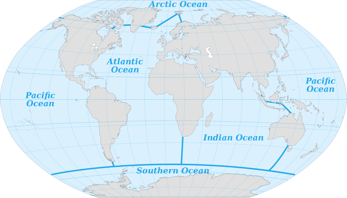
admin Common Ocean, Divided Oceans, international community, law of the sea, law of the sea example, law of the sea zones, Law of the Sea-an overview, What does the law of the sea do?, What is the law of the sea?, What law governs the sea?, When was the law of the sea created? 0 Comments the view on the some Paradigms in the Law of the Sea
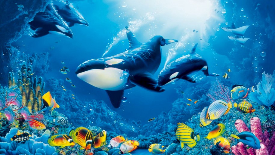
admin Arctic Circle, Arctic Ocean, homoiothermic, mammals, marine Arctic, marine Arctic flora and fauna, Marine fauna 0 Comments Marine fauna in the arctic
admin ARCTIC COUNCIL, ECONOMIC BENEFITS, OECD, OECD report 0 Comments OECD REPORT LAUNCH: THE ECONOMIC BENEFITS OF AIR QUALITY IMPROVEMENTS IN ARCTIC COUNCIL COUNTRIES
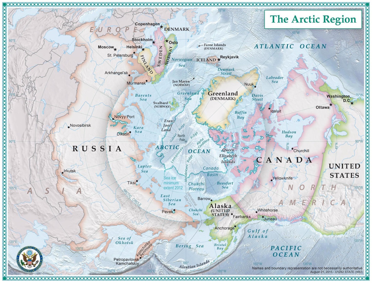
admin Angaran Shield, arctic, Baltic, Does the North Pole have rain?, Hercynian elements, land, northern Urals, Queen Elizabeth Islands, Severnaya Zemlya, Taymyr Peninsula, What are 3 interesting facts about the Arctic ocean?, What are 5 facts about the Arctic?, What are plants like in the Arctic?, What are the Arctic climate features?, What are the countries in the Arctic?, What are the differences between the Arctic and Antarctica?, What are the temperatures in the Arctic?, What continent is Arctic?, What is Arctic habitat?, What is the Arctic Pole?, What is the geography and climate of the Arctic?, What is the geography of the Arctic and Antarctic?, What is the North Pole called?, What is the symbol of the Arctic?, Which is bigger the Arctic or Antarctica? 0 Comments Physical Geography of arctic and its land
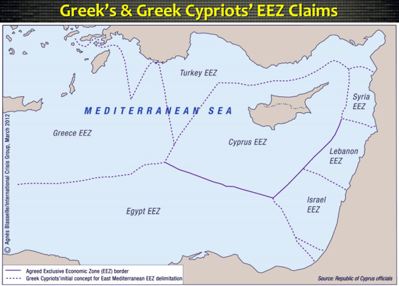
admin continental shelf, Eastern Mediterranean Basin, exclusive economic zone, Inter-State Maritime Delimitation, Legal Aspects, UNCLOS 0 Comments Legal Aspects of Inter-State Maritime Delimitation in the Eastern Mediterranean Basin
admin baselines, development of international law, ICJ, International Court of Justice, law of the sea, lawmakers, maritime delimitation, transit passage, United Nations Convention on the Law of the Sea 0 Comments The Development of the Law of the Sea by the International Court of Justice