Uruguay maritime claims about straight baselines and the outer limit of the territorial sea, the contiguous zone and the exclusive economic zone
the list of geographical coordinates of points for the drawing of straight baselines, and charts showing the straight baselines and the outer limit lines of the territorial sea, the contiguous zone and the exclusive economic zone.
The list of geographical coordinates and charts are annexed as Annex I and II, respectively, to the Law No. 17.033 of 20 November 1998 on the Maritime Spaces of the Republic of Uruguay

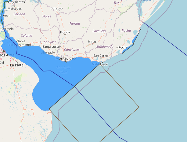
Straight Baselines : Uruguay is bordered by Brazil to the north and east, and
Argentina to the west. The southeast coastline of Uruguay faces the South Atlantic
Ocean and its southern coastline fronts on the Rio de la Plata. Overall, the entire
Uruguayan coastline from its border with Brazil to the entrance of the Rio de la Plata is
smooth with no major indentations. The mainland coastline does not contain localities
that are “deeply indented and cut into” or where there is “a fringe of islands.” With the
exception of a few isolated islets, there are no offshore islands.
Article 14 of its Act No. 17.033 of 20 November 1998 sets forth Uruguay’s baseline
claim (the geographical coordinates of the straight baseline turning points are
reproduced in Annex 1 of this study) and states:
The baseline for the measurement of the breadth of the territorial sea and of
other maritime areas of Uruguay are the normal and straight baselines
established in annex I (list of geographical coordinates and features specifying
the baselines) of this Act, including the straight line which marks the outer limit of
the Rio de la Plata from the maritime lateral limit with the Argentine Republic to
Punta del Este, in accordance with the provisions of the Treaty concerning the
Rio de la Plata and the corresponding maritime boundary of 19 November 1973.
The delineation of these lines is shown on the nautical charts which are annexed
hereto as Annex II to this Act.
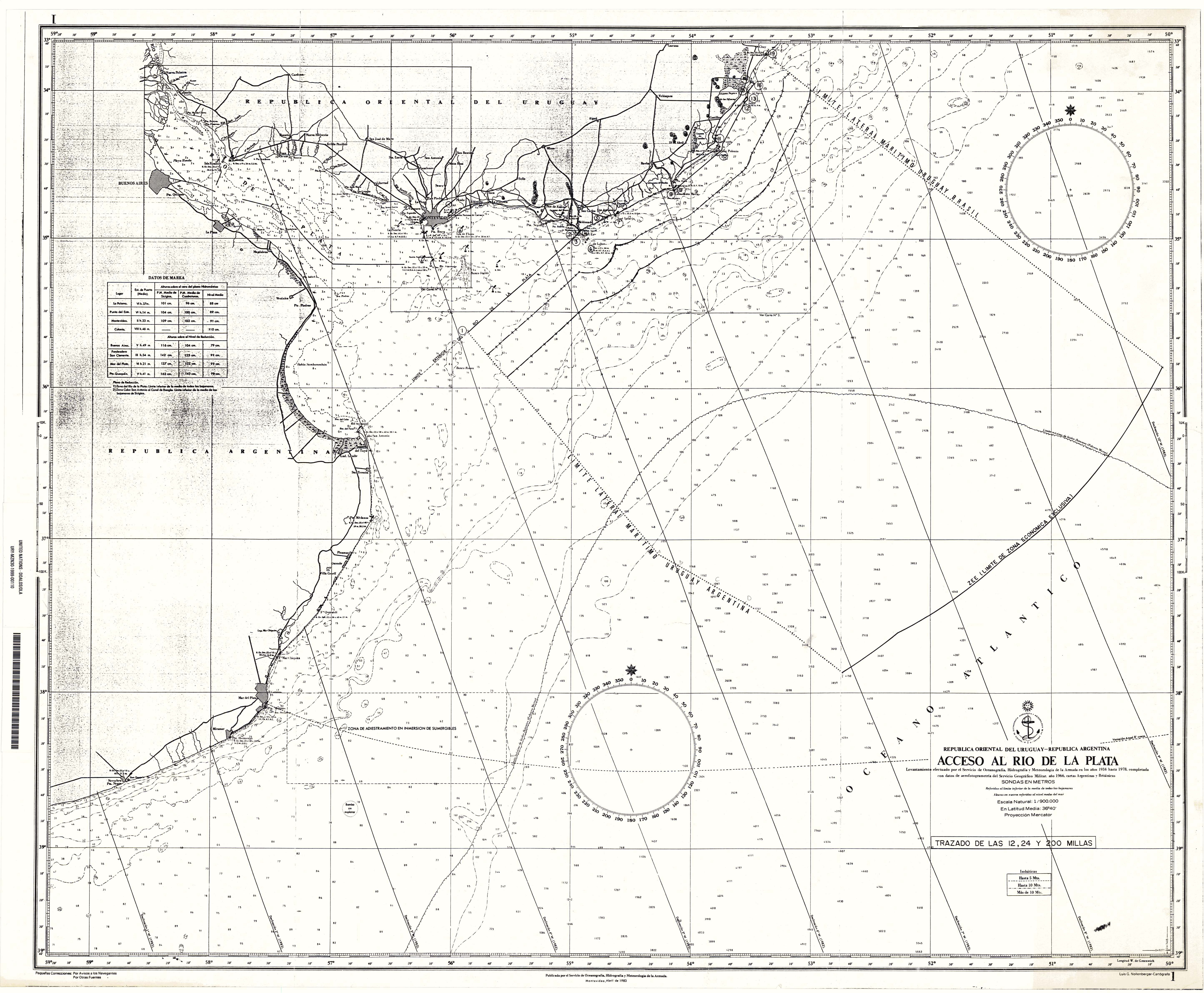
Uruguay has created 13 straight baseline segments ranging in length from 60 miles
(segment 1-2 across its half of the mouth of the Rio de la Plata) to 0.3 miles (segment
16-17; see Table 1).

Starting in the south, Uruguay’s first baseline segment of approximately 60 miles connects points 1-2 and is a part of the Rio de la Plata closing line that it established in an agreement with Argentina. On November 19, 1973, Uruguay and Argentina signed a treaty defining their lateral maritime boundary in the Rio de la Plata and a continental shelf boundary seaward of the river closing line. One provision of this treaty reaffirmed the closing line at the mouth of the Rio de la Plata between Punta del Este (Uruguay) and Punta Rasa del Cabo San Antonio (Argentina) established in the Joint Declaration on the External Limit of the Rio de la Plata of 1961 and the Protocol of the Rio de la Plata of 1964.
This Rio de la Plata closing line claim was protested by the United States in 1963. According to the United States, Argentina and Uruguay did not assert an historic claim to these waters, but rather their claim took into account the provisions of Article 13 of the 1958 Geneva Convention on the Territorial Sea and the Contiguous Zone regarding river closing lines. The U.S. protested on the grounds that this claim was counter to international law and that Article 13 “relates to rivers which flow directly into the sea which is not the situation of the Rio de la Plata which flows into an estuary or bay”. Thus, this is an invalid baseline from which to measure the breadth of its territorial sea because it exceeds 24 miles and because more than one state borders this body of water.
Basepoints 2 and 3 are situated on the west and south coast of Punta del Este, respectively, and the baseline between them is the normal baseline, or low-water line.
Along the next 7.5 mile stretch of smooth mainland coastline Uruguay has drawn straight lines between Points 3 and 4 (Punta del Vapor) and between points 4 and 5 (Punta Piedras). This coastline is neither deeply indented and cut into, nor fringed with islands. Thus, these segments exceed the provisions of Article 7 of the LOS Convention. And, in fact, the straight baselines have no impact on the outer limit of the territorial sea. About 6 miles seaward of the mainland in this area sits Islote de Lobos, a very small islet. Uruguay has established a low-water point (point 6) on this island from which to measure the territorial sea. The 12-mile limit drawn from this islet makes segments 3-4 and 4-5 irrelevant.
From point 5 through point 8, about 35 miles along the mainland coast, the baseline is the low-water line.
From point 8 (Cabo Santa Maria) to point 18 (Punta de la Coronilla) Uruguay has drawn 9 straight baseline segments, ranging in length from 0.3 miles (segment 16-17) to 24.6 miles (segment 9-10-see Table 1). While none of the baseline segments are excessively long, they all are drawn along a coastline that does not meet the LOS Convention geographic criteria.
Then, from point 18 (Punta de la Coronilla) to point 19, where the Brazil- Uruguay land boundary reaches the coast, Uruguay employs the normal (low-water line) baseline.
Uruguay’s mainland coastline from Punta del Este to the land boundary terminus with Brazil has a geographic consistency where the coastline, in its entirely, is relatively smooth with minor coastal curvatures. Yet, Uruguay has employed straight baseline segments in areas that have similar qualities as those areas where it has used the normal baseline, the low-water line. The straight baselines have enclosed very small areas that are not “sufficiently closely linked to the land domain to be subject to the regime of internal waters:” (as called for in Article 7(3) of the LOS Convention). Further, the straight baseline segments have virtually no impact on the outer limits of the territorial sea. There are no areas along the Uruguayan coastline where straight baselines would be appropriate.

Territorial Sea: Prior to its 1998 law, Uruguay claimed a 200-mile territorial sea. Its new Act 17.033 claim of a 12-mile limit is the maximum allowed by the LOS Convention. Uruguay’s territorial sea area, as drawn from its claimed straight baselines listed in Annex 1, encompasses approximately 2,200 square nautical miles (n. miles).
Article 2 of the Act states that the executive authority “shall also adopt the regulations applicable to the passage of warships through the territorial sea.” International law does not permit a coastal State to require a foreign warship to seek the prior authorization of, or notification to, the coastal State as a condition of conducting innocent passage through its territorial sea.
Contiguous Zone: The LOS Convention allows coastal States to claim a 24-mile contiguous zone for the purposes of “customs, fiscal, immigration or sanitary laws orregulations.” Uruguay’s 24-miles zone, as measured from its straight baselines encloses an area of approximately 4,450 square n. miles, or about 2,250 square n. miles seaward of the territorial sea limit.
Exclusive Economic Zone: The maritime boundary described below between Uruguay and the Government of Brazil, according to the original agreement, extended to the limit of the territorial sea. At the time the treaty was signed, both Brazil and Uruguay claim 200-mile territorial seas. Since then, both countries have reduced the breadth of their territorial sea limits to 12 miles. The 200-mile limit now reflects Uruguay’s exclusive economic zone limit as set forth in Article 4 of its 1998 Decree.
It is assumed that the change in the claimed legal status of the waters between Brazil and Uruguay has not affected the boundary treaty between the two States. From Uruguay’s declared straight baselines, the area of the exclusive economic zone is about35,950 square n. miles.
Article 6A of Uruguay’s Act asserts that it has jurisdiction over the establishment and use of artificial islands, installations and structures, “regardless of their nature and characteristics.” To the extent that Article 6A purports to provide exclusive jurisdiction over artificial islands, installations and structures in the EEZ that do not have an economic or resource-related purpose, it is not in conformity with international law.
Article 8 of the Act purports to condition the carrying out of foreign military exercises and activities in the EEZ on the prior authorization of Uruguay. A coastal States rights and jurisdiction within the EEZ are subject to the rights and duties of other States as provided for in international law (Article 56, LOS Convention). The rights specifically preserved for the ships and aircraft of all States in the EEZ include the high seas freedoms of navigation and overflight, and other internationally lawful uses of the sea related to those freedoms, without the requirement to provide prior notification to or obtain prior permission from the coastal State (Article 58, LOS Convention). Those uses include military exercises and activities, including the use of arms and explosives. Thus, Article 8 has no foundation in international law. Article 12 of the Act conditions the delineation of the course for the laying of submarine cables and pipelines on the continental shelf of Uruguay to the consent of the executive authority. Although the delineation of the course for the laying of “pipelines” requires the consent of the coastal State (Article 79, LOS Convention), there is no such requirement in the LOS Convention for the laying of submarine cables.
Maritime Boundaries:
Argentina: Uruguay and Argentina signed a continental shelf boundary on 19 November 1973. The boundary begins at the midpoint of the bilaterally-claimed Rio de la Plata closing line and extends seaward as an equidistant line, “determined by the adjacent coasts methods”. Initially, the continental shelf boundary extends as an perpendicular bisector to the closing line for about 113 miles. At this point Argentina’s Punta Medanos affects the course of the boundary. Later, Uruguay’s Isla de Lobos influences the equidistant line. The line terminates at a point 200 miles from Punta Medanos and Isla de Lobos.
Brazil: The maritime boundary agreement with Brazil was signed on July 21, 1972.The agreement established a single-line boundary that extends nearly perpendicular to the general direction of the coastline at an azimuth of 128 from true north, beginning at the mouth of the Chuy Stream. It terminates at the 200-mile limit of the respective States. And, given that this line is not equidistant to the two coasts, the 200-mile limit will intersect this boundary at different points.

Post Comment
You must be logged in to post a comment.